Footscray and Maidstone. Footscray is named after the village in Kent, Foot's Cray - a town located on the Cray River, and where in 1066 at the time of William the Conqueror, the manor belonged to Godwin Fot or Foot. Foot's Cray in Kent is near Maidstone, so that's where Maidstone on Ballarat Road, got it's name.
Braybrook and Sunshine. Braybrook is from Bray in Berkshire, England. Bray is Old English for brow or brow of hill. Braybrook Junction was the original name of Sunshine, the town that formed around the railway junction of the Ballarat and Bendigo Railway lines. In 1904, H.V. McKay, who operated the Sunshine Harvestor Works in Ballarat, acquired the Braybrook Implement Company at Braybrook Junction. In 1907 Braybrook Junction changed it's name to Sunshine, after McKay's Company
Deer Park and Ardeer The Mt Derrimut property near Deer Park was leased to the Melbourne Hunt Club in 1885 and they operated a deer park at the Club. The town was originally named Derrimut, after the Aboriginal Chief, and the railway station was first called Kororoit, Aboriginal for male kangaroo. The Derrimut State School, No. 1434, opened August 1874 and changed its named to Deer Park in 1890. Deer Park has been the home of explosives manufacturing since 1874 - the factory was later operated by ICI. Ardeer is a suburban development from the 1950s/1960s and is thought to be derived from the Deer Park name.
Rockbank. Descriptive name, due to all the rocks in the area, a common feature of the area and which are, I believe, basaltic lava. A school in the area opened in 1868 as New Cambridge and this changed its name to Rockbank in 1906 (State School No. 919)

Rockbank State School, No. 919, c. 1930s. The school has moved now but it used to be visible from the Western Highway.
Photographer: Charles Edward Boyles. State Library of Victoria Image H2008.122/365
Anthonys Cutting - the descent into Bacchus Marsh. The Argus newspaper reported on December 12, 1857 under the 'Contracts Accepted' heading A. Anthony, cutting and embanking, the Melbourne and Ballarat Road, south of Bacchus Marsh, not to exceed 2000 pounds. That's all I know about Mr Anthony.
Bacchus Marsh. Captain William Bacchus settled in the area in 1838. Captain Bacchus died February 26, 1849 aged 67. The old Western Highway entered Bacchus Marsh along the Avenue of Honour planted in August 1918 to honour Great War Soldiers. Bacchus Marsh is on the Werribee River and Lerderderg River - Werribee is Aboriginal for backbone or spine. Lerderderg is said to be Aboriginal from lardedairk - larh from stone house and darkk meaning peppermint gums.

Main Street or Western Highway, Bacchus Marsh, c. 1908
State Library of Victoria Image H96.200/1453
Myrniong Aboriginal for edible root. Myrniong was originally called Blow's Flat. Land for a Cemetery was set aside on December 24, 1860 as the Blow's Flat Cemetery, but two years later land was set aside for an Anglican Church in Myrniong, so it doesn't appear that Blow's Flat was used for long. Mr Blow as allegedly a sailor, who worked on a local farm in the area. You can read about him here, in this article from the Bacchus Marsh Express of August 27, 1892.
Pykes Creek Named for either brothers William Pyke (1815-1850) and George Pyke (1819-1855) who had Pykes Station on the Toolern Creek from 1838 to 1851 or named for Thomas Henry Pyke (1808 - 1861) who had the Morockdong Station on the Upper Werribee, adjoining Ballan, from July 1842 to March 1853.
Ballan Named after the town of Ballan in County Tyrone, Northern Ireland, which was the birthplace of squatter, Robert van Steiglitz. The town of Steiglitz, in the Brisbane Ranges, was named after Robert and his brother Charles. A Post Office was established at Ballan on July 8, 1844.
Gordon Blake says the town is named after early settler, George Gordon, however the book Names of Victorian Railway Stations said the name of the station, which opened May 1879, came from the Duke of Gordon, a Scottish Duke. A Registrar for Births and Deaths was appointed July 4, 1859, the land for the cemetery was gazetted on April 29, 1867 and the Gordon State School, No. 755, opened in 1873.
Wallace Named after J.C. Wallace who took up the Egerton Run in 1839 or possibly after John Wallace who took up the Ballark Station in April 1838, further south near Meredith. I favour the first suggestion as there are a number of references in the newspapers on Trove from the 1850s and 1860s of Mr J. Wallace near Mt Egerton or Wallace's Station near Mt Egerton. Mt Egerton is a town just south of Gordon. A school started in Wallace in 1870 and lasted until 1877 when it was replaced by State School, No. 2009 in 1878.

Wallace General Store and roadhouse, 1969. It was owned and operated by Peter and Maureen Kitchin. John Arnold is on the right, Jim Forrest on the left - they were driving for Fleetways.
Photo: Maureen Kitchin.
Bungaree Aboriginal for hut. The area was also known as Badger Hill and Claretown. Bungaree State School, No. 1960, opened September 1877. Another School called Bungaree School, No. 3147, opened December 11, 1889, in 1893 it was suggested that the name be changed to Badger Hill, but this didn't happen and from June 1909 it was known as Claretown and it closed March 1914. Claretown is five kilometres from Bungaree and it's name comes from County Clare in Ireland.
Leigh Creek Named after the Leigh River, which was named by John Wedge, who with his brothers, had a run on the Werribee River from 1836. Leigh is a river flat.
Warrenheip Aboriginal for trees on a mountain top or emu feathers on top, so obviously referring to the appearance of trees on the hill. State School No. 1591 opened in 1875, but a Wesleyan School had opened in 1860 (closed 1875) and a Catholic School in 1862 (closed 1877) Warrenheip is the junction of the Melbourne, Ballarat and Geelong Railway lines.
Ballarat From Aboriginal Balla, elbow or resting on one's elbow or Resting place. Originally called Yuilles Swamp after William and Arch Yuilles 10,000 acre Ballarat Station that they took up in 1838. Gold was discovered in 1851. You leave Ballarat through the Avenue of Honour, the trees of which were planted between June 1917 and August 1919. The Arch of Victory was officially opened by the Prince of Wales on June 3, 1920.
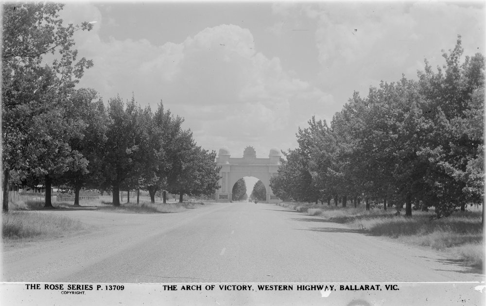
Arch of Victory, Western Highway, Ballarat, 1930s or 40s.
Trawalla Aboriginal for much rain or wild flood water. Trawalla State School, No. 1150, opened August 1, 1871. James Scullin, Australian Prime Minister from October 1929 to January 1932, was born at Trawalla and went to school there from 1881 to 1887.
Beaufort Named after Rear Admiral Sir Francis Beaufort (1774 - 1857) inventor of the Beaufort Scale to describe wind strengths and hydrographer to the Royal Navy. The Beaufort town site was gazetted February 25, 1861. The Beaufort Bomber, a World War Two bomber, was named after the Duke of Beaufort, whose ancestral home was near where they manufactured the Beauforts and whose family seat was once Raglan Castle. Raglan is the name of a neighbouring town, not on the Highway, and was named for Lord Raglan (1788 - 1855) Commanding Officer of the British troops at Crimea and youngest son of the 5th Duke of Beaufort. The Beaufort area was known as Fiery Creek. Fiery Creek was named by Thomas Chirnside as the creek bed looked like it was smoking when it dried out in the summer. A Post Office was established at Firey Creek in August 29, 1844.

Neill Street, part of the Western Highway, looking east, Beaufort, 1890s.
Museum Victoria http://collections.museumvictoria.com.au/items/765908
Buangor Aboriginal for pointed hill, from a hill on a nearby Station owned by Colin Campbell on Firey Creek. The Buangor village site was gazetted on November 20, 1865. A school opened in 1872 and it was replaced by Buangor State School, No. 2072 in July 1878.
Dobie Place Names of Victoria says that 'Jack Dobie was the station manager at Lanengeren (Langhi Gheran). The area was known as Dobie's Bridge until 1937, then Dobies'. However Names of Victorian Railway Stations says Dobie was named for 'William Dobie, who settled in that locality in 1848, took up land and became a wealthy grazier. He died in the early fifties and was buried on his estate' Dobie State School, No. 1468, opened on December 4, 1874. The School opened as Dobie's Bridge and changed its name to Dobie in 1937. the School closed in June 1946.
Ararat Ararat is the resting place of Noah's Ark in the Bible. Blake says the town was named by Horatio Spencer Wills as he rested there (like the Ark) on his journey from the Molongo District (around where the Australia Capital Territory is now located) to the Port Phillip District in 1840. You can read more about Mr Wills in the Australian Dictionary of Biography, here. Gold was discovered at Ararat in 1856.
Armstrong Named after John Armstrong who occupied the 80,000 acre Allanvale Station in 1854. Gold was discovered there in 1855. The town was originally called Armstrongs and State School, No. 784, opened in October 1865 and closed in 1948.
Great Western Blake says that the Great expressed the gold miners optimism for the 'lead's gold bearing qualities' - gold was discovered there in January 1858. Great Western State School, No. 860, opened in 1867. The Greater Western vineyard was established by Joseph Best in the 1860s.
Stawell Sir William Foster Stawell (1815 to 1889) was appointed Victorian Attorney General in 1851 and became Chief Justice of Victoria in 1857. Gold was discovered in Stawell in 1853. It was originally called Pleasant Creek, obviously a descriptive name.
Deep Lead A descriptive name. Gold was discovered there in 1857 but the leads were deep underground. There was a school at Deep Lead (No. 721) from 1859 and it closed in 1967.
Dadswell Bridge The bridge is over the Mt William Creek was constructed by engineer, Thomas William Dadswell (1828 - 1908) in 1866/67. Thomas and his wife Helena also owned the nearby hotel. You can read more about Thomas Dadswell here. Dadswell Bridge School (No. 3391) opened June 1901.
Horsham Named after Horsham in Sussex in England by squatter James Monkton Darlot, who had taken up the 102, 400 acre Brighton station on the Wimmera River in 1843. Wimmera comes from the Aboriginal term woomera - a throwing stick. Horsham means 'where horses were kept. A Court was established at Horsham in May 1847 and a Post Office in July 1848 - the site for the village of Horsham was gazetted in May 1850.

Firebrace Street, part of the Western Highway, at Horsham, early 1960s.
Colour Views of Horsham postcard set State Library of Victoria Image H2014.76/115e
Wail Aboriginal word for Curlew (a type of bird) The township of Wail was gazetted June 9, 1873. In spite of the fact that Pimpinio and Wail were only six miles apart (or the Railway stations were) and had a relatively small population (for instance in 1891 there were 14 dwellings and 72 people in Pimpinio and by 1901 there were only 11 dwellings and 67 people), there were actually eight schools that bore the Wail or Pimpinio name -
Wail No. 3086 Operated February 1891 to September 1897, then operated from September 1911 to July 1964.
Wail South East No. 3141 Opened September 1891 and closed 1901, name changed to Pimpinio South in 1894
Wail West No. 3329 Opened May 1899 and closed October 1934 and students transferred to Pimpinio West No. 2824.
Wail South No. 2824 also called Pimpinio West - operated May 1887 to May 1954
Wail North No. 1779 - operated October 1876 to March 1910, name changed to Wail South in 1893
Wail East No. 3981 - operated March 1919 to July 1964
Wail South No. 2585 operated June 1884 closed end 1885
Pimpinio No. 1439, commenced September 7, 1874
Dimboola The name is thought to have been taken from Dimula in Sri Lanka. Originally called Nine Creeks, a descriptive name. The site for the Presbyterian Church was gazetted in April 1863. the Police Station site in June 1864 and the Cemetery in April 1867. Dimboola School, No. 1372 opened May 23, 1870.
Gerang Gerung Aboriginal from jerung - a leaf or branch. Apparently also just called Gerang. Gerang State School No 2618 opened September 9, 1884. The Railway line from Dimboola to Serviceton opened January 1887, Gerang was the first stop from Dimboola.
Kiata Aboriginal for summer heat. There were three Schools that bore the Kiata name -
Kiata East No. 2429 - Opened September 1881 closed August 1902, re-opened September 1907 and closed May 1927
Kiata No. 2769 - Opened August 16 1886 and closed December 13 1968
Kiata No. 2200 - opened November 1, 1879 the name changed to Kiata West in 1890. Building moved to Salisbury in April 1901 and name changed to Salisbury in 1905. Closed September 1947.
Salisbury Blake says the town is named after Salisbury Plain in Wiltshire, however Names of Victorian Railway Stations says the railway station is named for Lord Salisbury. The Marquis of Salisbury was the British Prime Minister on three occasions between 1885 and 1902. The town was also called Kiata West. It is two and a half miles from Kiata on the Dimboola to Serviceton railway line.
Nhill Various intrepretations as to the meaning of the name - From the Aboriginal nyell - place of spirits or from niall meaning Corrobboree ground. Squatter, Dugald Macpherson, took up the Nhill Station in March 1849 but called it at the time Nyill thought to mean pegging place for skins. The Nhill township was gazetted November 22, 1880 and the School, No. 2411, opened June 13 1881.
Kaniva Once again, there are various theories as to how the town was named. The book Names of Victorian Railway Stations says it is a corruption of Kanizba the name of a town in Hungary - a large number of Germans and Austro-Hungarians were amongst the earliest settlers in the area. Blake says it is named after Kinnivie, in Durham England as an early map had a shepherd's hut named as Kinivae. The original name for the place was Budjick or Budjik - Aboriginal for tomahawk. A Publican's licence was granted to the town in November 28, 1881 and Kaniva School, No. 2531, commence August 1883 - it was originally known as Budjik Hill School.

Kaniva, 1950. This is the Western Highway.
Lillimur From the Aboriginal lillima meaning bone. The original town of Lillimur was six miles south of the present town and a School No. 2399, opened there in June 1881 and closed in 1920, reopened 1922 and closed in 1952. This school, originally called Lillimur and changed its name to Lillimur South when the railway station was named Lillimur. Lillimur North School, No. 2400, opened June 1881 as Kaniva, changed its name to Lillimur North in 1882 and to Lillimur presumably around the time the Railway Station opened in January 1887. The School closed in 1952.
Serviceton Serviceton is not actually on the Western Highway, but it's the last town before the South Australia border and the junction of the Victorian and South Australian railway lines. The town was proclaimed on January 25, 1887 and established for the railway - it provided accommodation and refreshments for staff, a maintenance depot and, as this was before Federation, a Customs Office as well. Serviceton was named after Sir James Service (1823 - 1899) Premier of Victoria from March to August in 1880 and then from February 1883 to March 1886.
Dukes Highway The Western Highway becomes the Dukes Highway in South Australia. This was named to commemorate the visit of the Duke and Duchess of York who visited Australia in 1927 (and opened Parliament House in Canberra on May 9 whilst they were here). The Royal couple later became George VI and Queen Elizabeth, the parents of our current Queen. An article in the Adelaide Mail of April 2, 1927 talks about this proposed name. Mr W. James of the National Roads Association wanted it to be called the Duke's Highway and it must be something to compare to the Princes Highway. You can read the Article here. The Princes Highway was originally known as the Gippsland Road, but was changed in 1920, after the visit of Edward, Prince of Wales (later Edward VIII, then the Duke of Windsor. The Prince was born June 1894 and died May 1972, he is the uncle of Queen Elizabeth).
Sources
- Aboriginal Place Names and their meanings by A.W. Reed (A.H & A.W Reed, 1967)
- Australian Dictionary of Biography http://adb.anu.edu.au/
- Concise Oxford Dictionary of English Place Namesby Eilert Ekwall (Oxford University Press, 1951)
- Lost & almost forgotten towns of colonial Victoria : a comprehensive analysis of census results for Victoria, 1841-1901 by Angus Watson (published by the author, 2003)
- Names of Victorian Railway Stations by Thos. O'Callaghan (Victorian Railways, 1918)
- Pastoral Pioneers of Port Phillip by R.V Billis and A.S. Kenyon (Stockland Press, 1974)
- Place Names of Victoria by Les Blake (Rigby 1977)
- Trove Digitised Newspapers http://trove.nla.gov.au/newspaper/
- Victorian Government Gazette online Archive 1836 - 1997 http://gazette.slv.vic.gov.au/
- Victorian Places website www.victorianplaces.com.au
- Vision and Realisation: a centenary history of State Education in Victoria (Education Department of Victoria, 1973)
No comments:
Post a Comment